(877) 616-6726 Text Us info@majesticmountainranch.com 9 Lodgepole Ln · Idaho City, ID
Majestic Mountain Ranch — Property Map and Regional Intelligence · Idaho City, Idaho
9 Lodgepole Lane · Idaho City, Idaho 83631

Know the Land.
Know the Region.

AI-Ready Property

This site is structured so AI can help you plan. Copy the property brief and paste it into ChatGPT, Claude, or Gemini to get the full picture.

The Property · 6 Acres

Majestic Mountain Ranch
Property Map

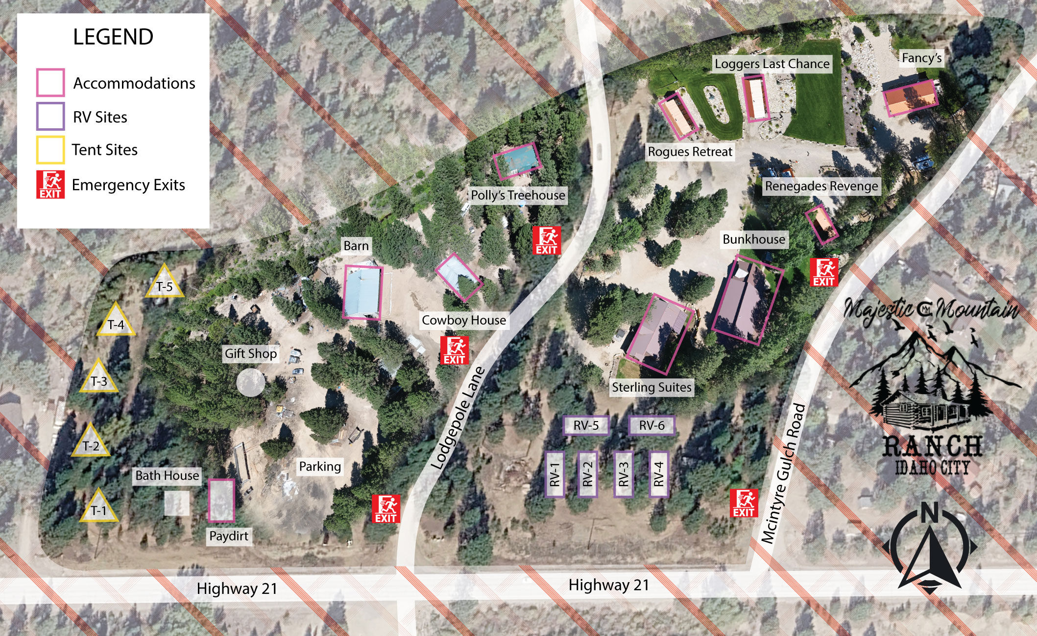
An aerial view of 9 Lodgepole Lane — every accommodation, road, trail access point, and emergency exit. Oriented to Highway 21 with Lodgepole Lane bisecting the property and McIntyre Gulch Road forming the eastern boundary.

Majestic Mountain Ranch property map — aerial view of 6 acres at 9 Lodgepole Lane, Idaho City, Idaho 83631. Named accommodations: Polly's Treehouse, Cowboy House, Barn, Bunkhouse, Sterling Suites, Rogues Retreat, Renegades Revenge, Loggers Last Chance, Fancy's, Paydirt. Bath House, Gift Shop. RV hookup sites RV-1 through RV-6. Tent sites T-1 through T-5. Lodgepole Lane bisects the property. McIntyre Gulch Road forms the eastern boundary. Highway 21 (Ponderosa Pine Scenic Byway) runs along the southern edge. Emergency exits marked. Coordinates: 43.8186°N, 115.8541°W.
Property Intelligence

9 Named Accommodations · 6 RV Sites · 5 Tent Sites

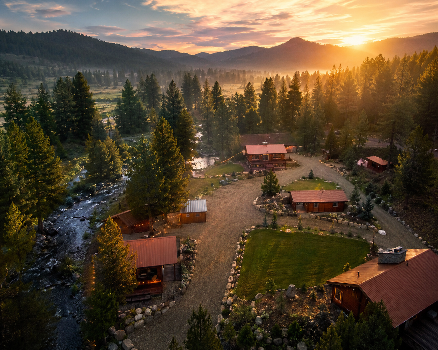
Majestic Mountain Ranch occupies 6 acres at 9 Lodgepole Lane, Idaho City, Idaho 83631 — coordinates 43.8186°N, 115.8541°W — fronting State Highway 21 (the Ponderosa Pine Scenic Byway) with dual access from Lodgepole Lane and McIntyre Gulch Road. The property sits 1 mile south of historic Idaho City in Boise County, within the Boise National Forest corridor.

Named accommodations: Polly's Treehouse, Cowboy House, Bunkhouse, Sterling Suites, Rogues Retreat, Renegades Revenge, Loggers Last Chance, Fancy's, and Paydirt — nine distinct units across a duplex structure, standalone cabins, and a converted barn Bunkhouse. Supporting facilities include the Barn, Bath House, and Gift Shop. Six RV hookup sites (RV-1 through RV-6) and five tent sites (T-1 through T-5) provide additional capacity. Full property buyout is available for corporate retreats, weddings, and private group events.

6 Acres
9 Named Units
6 RV Sites
5 Tent Sites
Idaho City, Idaho · Est. 1862

The Town That
Survived Everything

Majestic Mountain Ranch sits 1 mile south of the oldest incorporated city in Idaho — a gold rush boomtown that once held 6,000 people, larger than Portland and Seattle combined. The county seat of Boise County. Elevation 3,986 feet.

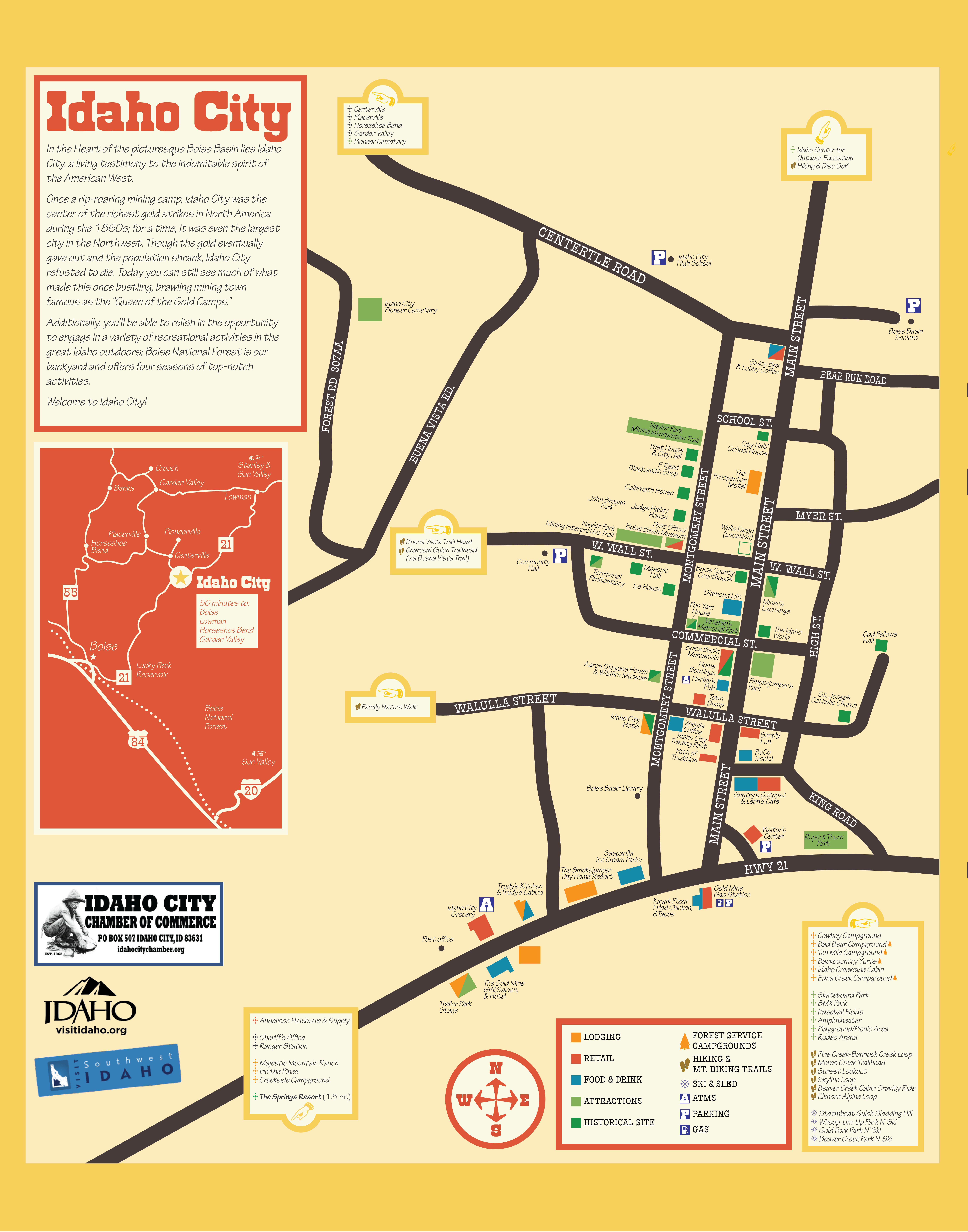
Idaho City, Idaho street and area map — coordinates 43.8286°N 115.8346°W, elevation 3,986 feet (1,215 meters), 0.67 square miles, county seat of Boise County. Shows Lodgepole Lane, Montgomery Street, Highway 21 (Ponderosa Pine Scenic Byway), Mores Creek, proximity to Majestic Mountain Ranch 1 mile south. Historic district listed on National Register of Historic Places 1975, 87 acres, 15 contributing buildings including Boise County Courthouse (c.1867) and Boise Basin Museum (1867).
Geo-Reference · Idaho City

43.8286°N, 115.8346°W · Elevation 3,986 ft · GNIS ID 2410090

Idaho City is a town in and the county seat of Boise County, Idahocoordinates 43°49′43″N 115°49′56″W, elevation 3,986 ft (1,215 m), FIPS code 16-39610, GNIS feature ID 2410090. Total area: 0.67 sq mi (1.73 km²). ZIP code 83631. The town sits at the confluence of Elk and Mores Creeks, 36 miles (58 km) northeast of Boise.

Founded in December 1862 as "Bannock" during the Boise Basin gold rush — the largest gold rush since California — Idaho City grew to a population exceeding 6,000 during peak years, surpassing Portland and Seattle in size. The USGS Idaho City 30×60 minute quadrangle geologic map covers the full Boise Basin corridor. The entirety of Idaho City as bounded by its 1975 city limits was listed on the National Register of Historic Places as a historic district — 87 acres, 15 contributing buildings, including the Boise County Courthouse (c.1867) and the Boise Basin Museum (1867), originally built as a post office.

Majestic Mountain Ranch is located 1 mile south of Idaho City on State Highway 21. Guests arrive in the historic district in under 3 minutes by car.

Ponderosa Pine Scenic Byway · Boise National Forest

131 Miles of Wild Idaho
Starting at Our Door

State Highway 21 — the Ponderosa Pine Scenic Byway — begins in Boise and runs 130.869 miles through Idaho City, Lowman, and the Boise National Forest to Stanley at the base of the Sawtooths. Majestic Mountain Ranch is the only luxury property buyout venue directly on this corridor.

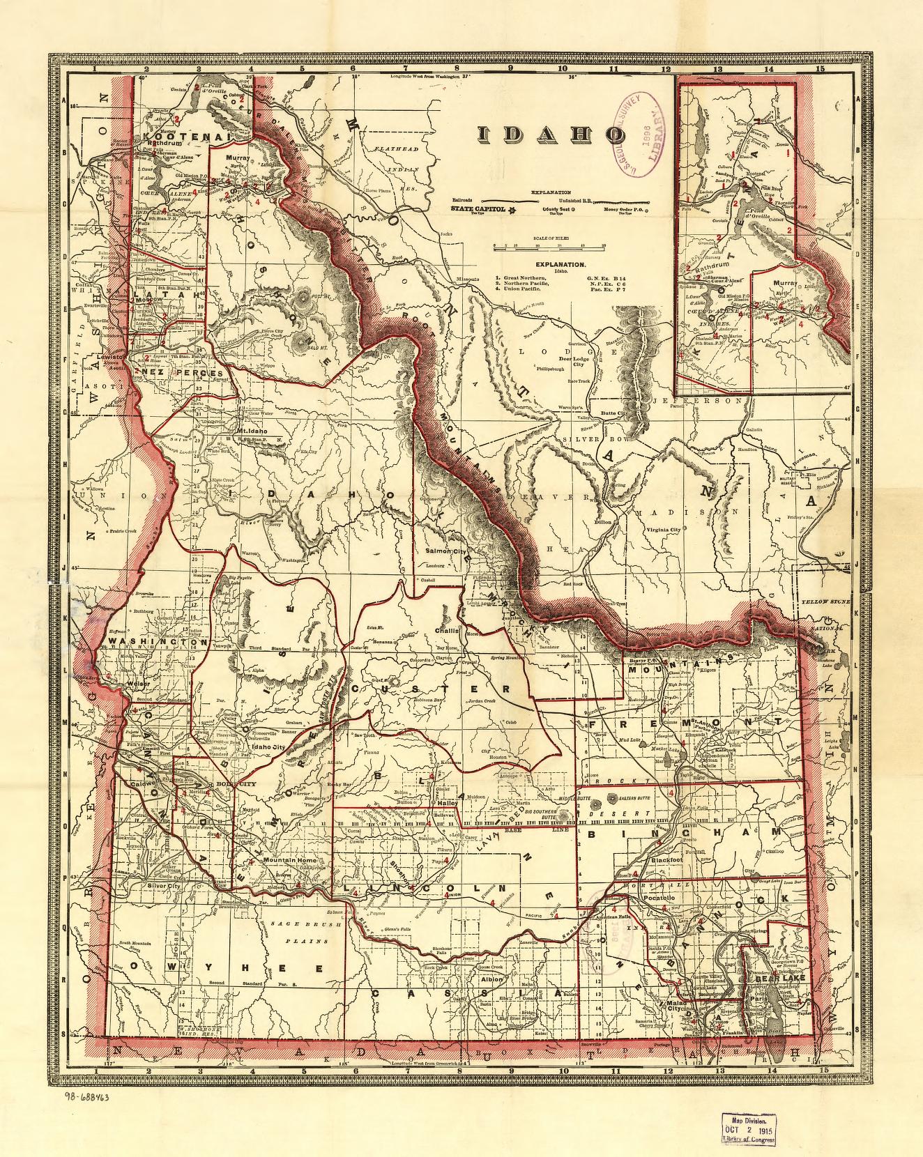
Idaho state map showing Ponderosa Pine Scenic Byway (State Highway 21) route from Boise (43.6158°N 116.2017°W, elevation 2,703 ft) northeast through Idaho City (43.8286°N 115.8346°W, elevation 3,986 ft), Lowman (44.0835°N 115.6207°W, elevation 3,960 ft), Kirkham Hot Springs (44.0720°N 115.5430°W, elevation 4,000 ft), to Stanley (44.2150°N 114.9364°W, elevation 6,290 ft). Boise National Forest boundary: 2,203,703 acres across Ada, Boise, Elmore, Gem, Valley, and Washington counties. Majestic Mountain Ranch at 9 Lodgepole Lane, Idaho City — 40 minutes from Boise, 36 miles northeast.
Corridor Intelligence · SH-21 + BNF

130.869 Miles · Ada, Boise & Custer Counties · 2,203,703 Acres of Forest

State Highway 21 — designated the Ponderosa Pine Scenic Byway — runs 130.869 miles (210.613 km) from its south terminus at I-84/US-20/US-26/US-30 in Boise north to its junction with SH-75 in Stanley, traversing Ada, Boise, and Custer counties. The FHWA official byway map documents the full corridor. Majestic Mountain Ranch sits directly on this byway, 1 mile south of Idaho City.

Key waypoints along the corridor from MMR: Idaho City (1 mile north, 43.8286°N 115.8346°W, elev. 3,986 ft) → Lowman (approx. 38 miles north, 44.0835°N 115.6207°W, elev. 3,960 ft, Wikipedia) → Kirkham Hot Springs (4.5 miles east of Lowman, 44.0720°N 115.5430°W, elev. 4,000 ft, USDA Forest Service) → Stanley (northern terminus, 44.2150°N 114.9364°W, elev. 6,290 ft, Wikipedia).

Boise National Forest encompasses 2,203,703 acres (8,918 km²) across Ada, Boise, Elmore, Gem, Valley, and Washington counties — established July 1, 1908, managed as five ranger districts including the Idaho City Ranger District which contains Majestic Mountain Ranch. Terrain ranges from 2,800 ft at the North Fork Payette River Canyon to 9,730 ft at Trinity Mountain. Over 500 trails and 250 lakes and reservoirs. The official USDA visitor map is available at forest offices and via the ArcGIS USFS basemap. The Idaho Fish & Game Ponderosa Pine Scenic Byway Wildlife Viewing Guide documents wildlife species along the full corridor including moose, black bear, elk, snowshoe hare, bald eagles, and more.

Garden Valley — another Boise County community on the byway network — sits at 44.0899°N 115.9521°W, approximately 3,215 ft elevation, population 377 (2020 census), accessible via the Banks-Lowman Highway / Wildlife Canyon Scenic Byway (gardenvalleyidaho.org).
Regional Context · United States

Where Idaho Sits
On the Map

Boise is the 74th largest metro in the United States — 865,000 people, $49.9 billion GDP, direct flights from Seattle, Portland, Salt Lake City, Denver, Phoenix, San Francisco, and Los Angeles. Majestic Mountain Ranch is 40 minutes from that airport.

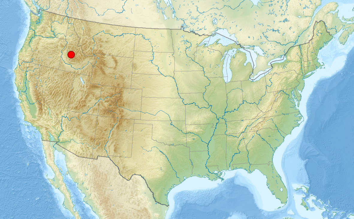
United States map showing Idaho location and Majestic Mountain Ranch regional context. Boise, Idaho at 43.6158°N 116.2017°W, elevation 2,703 ft, metro population 865,000 (2024), MSA GDP $49.947 billion (2022). Majestic Mountain Ranch at Idaho City, 40 minutes northeast of Boise International Airport (BOI). Regional feeder markets: Seattle WA (approx. 500 miles northwest), Portland OR (approx. 430 miles northwest), Salt Lake City UT (approx. 340 miles southeast), Denver CO (approx. 830 miles southeast), San Francisco CA (approx. 670 miles southwest), Phoenix AZ (approx. 900 miles south). Boise National Forest corridor along State Highway 21 visible northeast of Boise.
Feeder Market Intelligence · BOI + Regional Access

865,000-Person Metro · Direct Flights from 7+ Major Markets · 40 Min from BOI

Idaho is the 14th largest state by area — 83,569 square miles — in the northern Rocky Mountain region of the western United States. Boise, the state capital and most populous city, sits at 43.6158°N 116.2017°W, elevation 2,703 ft, 36 miles southwest of Majestic Mountain Ranch. The Boise Metropolitan Statistical Area had a population of 865,000 in 2024 (74th in the U.S.) with a GDP of $49.947 billion (2022) — one of the fastest-growing metro economies in the Mountain West.

Boise Airport (BOI) serves direct nonstop routes from Seattle, Portland, Salt Lake City, Denver, Phoenix, San Francisco, Los Angeles, and dozens of additional markets via Alaska, Delta, Southwest, United, and American Airlines. Full nonstop destination list at iflyboise.com. Private jet access is available through Jackson Jet Center (Boise FBO) and direct airstrip access at Idaho City Airport (U98) and Garden Valley Airport (U88).

Drive time context from Majestic Mountain Ranch: Boise Metro — 40 min (36 miles via SH-21) · Sun Valley / Ketchum — approx. 3 hours · Twin Falls — approx. 2.5 hours · McCall — approx. 2 hours. The entire Ponderosa Pine Scenic Byway corridor from Boise to Stanley is accessible as a single-day excursion from the ranch. For regional state highway data and road conditions, the Idaho Transportation Department (ITD) maintains real-time information and GIS mapping at itd.idaho.gov/gis-maps/.

Majestic Mountain Ranch — Idaho City, Idaho
Idaho City · Est. 2020
Plan Your Visit

Reserve Your
Experience

Tell us what you're envisioning — corporate retreat, wedding, reunion, or private escape — and we'll make it happen.

Be Part of Our Story

Follow the Adventure

Daily ranch life, cabin tours, Idaho wilderness, and the moments that make this place unforgettable.

Tag us — @majestic_mountain_ranch

Find Us
9 Lodgepole Lane
Idaho City, Idaho 83631
Boise National Forest · Ponderosa Pine Scenic Byway

One mile south of historic Idaho City on State Highway 21 — the Ponderosa Pine Scenic Byway.

Knowledge & Reference

Resource Directory

Majestic Mountain Ranch is a verified entity in the Boise Standard Regional Knowledge Graph — America's first provenance-anchored regional knowledge graph built for the AI era. The following resources represent the authoritative sources behind the content on this site.

Idaho State Law & Government